Why Street Patterns can Make or Break Buses

For a couple years in high school I took the DC Metro to the bus to get home. While I often exaggerate the numbers when talking about my commute, even today Citymapper says it would take at least an hour to get home. Because of bus bunching, on a route with 20 minute headways no less, it would sometimes take me up to an hour and a half. Once I learned how to drive, if I left before rush hour it was a 15-20 minute drive depending on how many stoplights I hit. The bus route did not have all that many stops on it, but I always wondered why the bus's route felt so indirect. The answer was a combination of 1950s style planned suburbs, a lack of investment in local buses, and a decision to focus on coverage instead of a ridership.
A Little History
Photo by Blake Wheeler / Unsplash

As a concept, planned communities have been around for a long time. Both Washington D.C. and New York City were once planned communities, and older style plans generally designed off of grids since people could not rely on cars to get around. In the 1920s, pedestrians were still the primary users of public street space despite the increasing spread of the automobile. This, somewhat predictably, led to a large number of pedestrian casualties. While initial outrage was actually against car makers, the car industry fought back. Various pro-auto groups eventually created the term jaywalking and outlawed it, dramatically changing the way Americans see street space to this day.
Turning over streets to cars meant that traditional grids in the downtowns of many cities became quite dangerous for kids and pedestrians. This led to a switch in the 50s and 60s when many planned communities changed to loop and cul-de-sacs designs. A joint article from professors at MIT and UC Berkeley in 2004 goes in depth on the topic, but the main takeaway is that cul-de-sacs have fewer vehicle collisions than traditional grid layouts. The tradeoff for quieter roads though is that these communities with cul-de-sacs are also very auto-dependent, because the same windy roads that keep cars moving slowly and keep vehicle traffic down also make it difficult for pedestrians to get to faster moving arterial roads where offices, stores, and buses are located.
The 1/4 Mile Rule
The layout of suburban communities matters a lot more for transit planners in the context of the vague rule that people are willing to walk about a 1/4 mile to the bus. In a blog post, public transit consultant Jarrett Walker pointed out the rule does not actually have a large body of research behind it, and that it is not a strict cutoff. Notably, most people are willing to walk a little further to faster services (like the train) (El Geneiedy et al., unformatted pdf here). The 1/4 mile rule means a bus stop at the entrance to a loop and lollipop neighborhood probably will not cover most of the residents.
For a long time (and often nowadays as well), planners would simply put a 1/4 mile buffer around bus stops and consider that as the coverage of the bus stop. This is unrealistic at best and will likely lead to a bus system missing its ridership targets.
In 2015, Stephen Wheeler at UC Davis published a paper on the 27 different types of street networks that make up most of the cities and suburbs in the United States. Wheeler called these suburbs "loops and lollipops", which the Washington Post wrote summarized here.
It is Difficult to Cover Loops and Lollipops Effectively
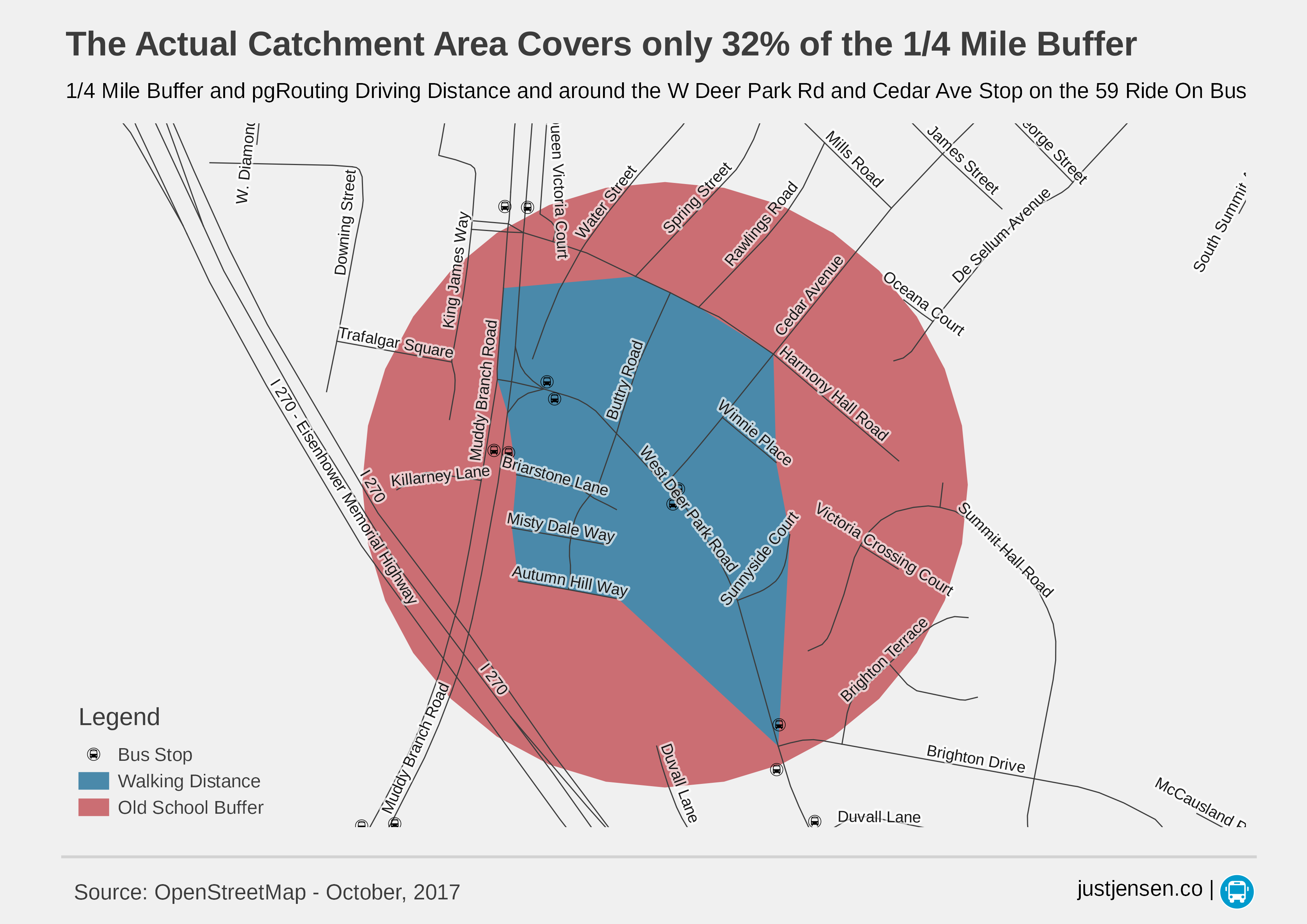
I stole the above photo from a companion piece on using pgRouting to calculate transit catchment areas. While I only show the buffer around a single bus stop, there are several areas in the neighborhood which the bus does not cover. This is especially frustrating since the bus stops are spaced close together for coverage purposes, slowing down the bus even more. Roads like Summit Hall Road are almost impossible to cover in an efficient way, particularly at the levels of funding we are willing to provide in the United States.
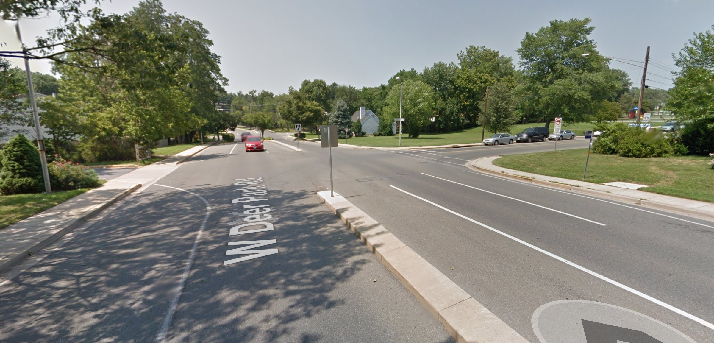
The map above also does not take into account the quality of pedestrian facilities in the area. Even if the neighborhood was layed out as a grid, West Deer Park Road does not have a crosswalk at the intersection. This means that bus riders have to cross a road with fast moving vehicles without protection once every day, as you can see in the photo from Google Street View below.
How do we fix it?
We do not need Manhattan levels of density to provide quality bus service. Just look at Mount Pleasant in Washington D.C.
Mount Pleasant has good bus coverage, but townhouses and duplexes make up most of the units in the neighborhood. Overall, Montgomery County does provide relatively good transit options and has done a lot of work supporting smart growth. It is also hard to retrofit past suburban developments, even if it would make it easier to provide public services. Instead, it is far more important to change zoning laws to allow infill development in gridded areas while also preventing future developments from carving out loops and lollipops.