Streetmix, A Street Section Builder for Activists and Professionals Alike
Back in 2013, San Fransisco's Department of Public Works wanted to find ways to facilitate public feedback for the Second Street Improvement Project. Traditionally, planners have used paper cutouts and drawings to get feedback from the public, but this is time consuming, not very flexible, and makes it difficult to collect feedback in between public outreach meetings.
This dilemma led to the creation of Streetmix, a website and tool that allows users to make visually appealing and detailed street cross sections of streets with ease. The tool integrates with design guides from the National Association of City Transportation Officials (NACTO) to provide suggestions for lane width, and when lanes are likely too wide or too narrow to be realistic. It is worth noting that the same design principles that work well in urban contexts likely do not match those that are necessary for highways or other long distance high capacity roads. The Federal Highway Administration's (FHWA) has officially endorsed NACTO's guidelines, which does make it feasible for highway engineers to follow these guidelines as well.
As an alternative, there is also the Abu Dhabi Urban Street and Utility Design Tool, which allows for top down views of the road as well. However, it is not as easy to use and does not produce nearly as attractive cross sections.
All of Streetmix's source code, including SVG exports of the illustrations, are on Github.
Using the Tool
As somebody who has used AutoCAD, Revit, and Solidworks (admittedly, less applicable), I still find Streetmix incredibly impressive. While it certainly does not replace professional CAD tools for detailed design work, it flexibly allows users to select different street elements, adjust widths, and get feedback. The video below from the creators provides a little more information, although some of the examples are on the whimsical side.
The editor allows you to place the following street elements:
- Sidewalk
- Sidewalk with Tree
- Bike rack
- Bench
- Wayfinding Sign
- Sidewalk with a lamp
- Parklet
- Transit Shelter
- Buffer
- Bike Lane
- Bus/Streetcar/Light Rail lanes
- Parking/Driving/Turning Lanes
Each of these has multiple options, like making the buffer a planting strip or a just a stripe on the ground. Lanes can be shared between bicycles and other modes, and can be painted different colors. On the sides of the road, you can select different building types to match the aesthetic of the street. The only thing you need to know to get started is how wide your street is, and perhaps how wide the lanes are.
An Example: BRT on MD-355 in Montgomery County, MD
Several years ago, Montgomery County announced they would try to implement bus rapid transit (BRT) on several corridors in the region. I actually did a policy of this project back in graduate school, although a lot of it was complaining about the lack of transparency from Montgomery County Department of Transportation (MCDOT) and the special BRT task force. While the first route will be on US-29 (the slides actually use Streetmix!), I wanted to focus on MD-355 since it will likely be the next section. The list of possible alternatives is here. Multiple alternatives have no dedicated lanes whatsoever on Wisconsin Ave between Bethesda Metro and Tuckerman Lane.
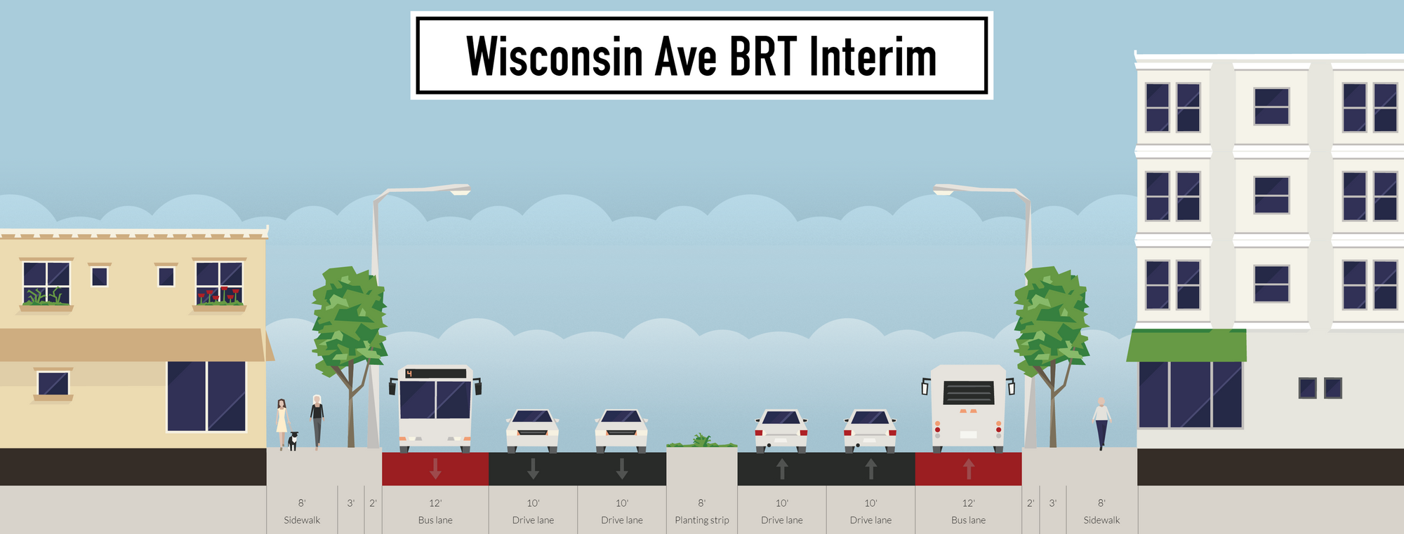
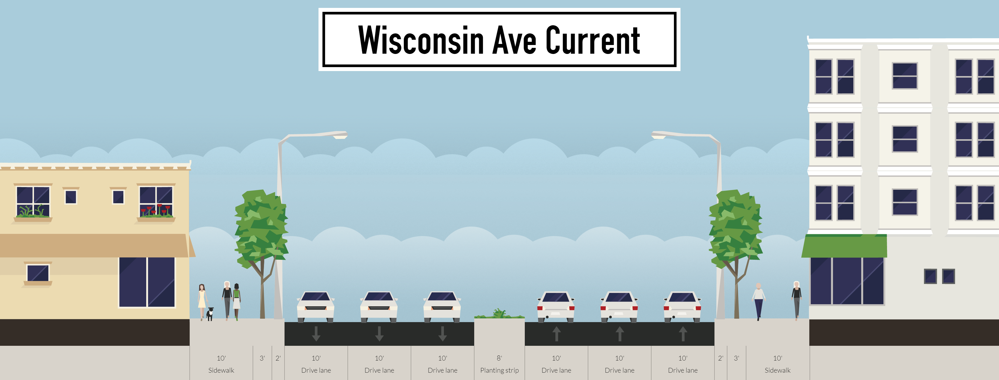
Anecdotally, this 3 mile section is incredibly congested at most times during the day, and it will likely only get worse as new businesses move into Bethesda. I'm not a particularly big fan of the argument that transit will reduce congestion, . Currently, there are three 10' lanes in each direction with 15' sidewalks and an 8' buffer in the middle. This gives us a comfortable 98' to work with (I got all these numbers using the DaftLogic Distance Calculator.
Setting everything up with these parameters is pretty easy, and generates the cross section below. If you're reading on a smartphone, make sure to switch into landscape mode. If you want to play around with the design yourself, click here.
This last section connecting to the metro station is important though, since it is typically so congested. An interim option that would slow down traffic and provide bus priority would be to change one travel lane each way to peak hour bus lanes, and reduce the other travel lanes to 10'. These changes would follow the NACTO recommendations for lane widths in cities, while allowing buses to move well in congestion. Converting them to parking lanes with delivery sections during the day and at night would buffer pedestrians from the fast moving traffic they experience there during off peak hours currently.
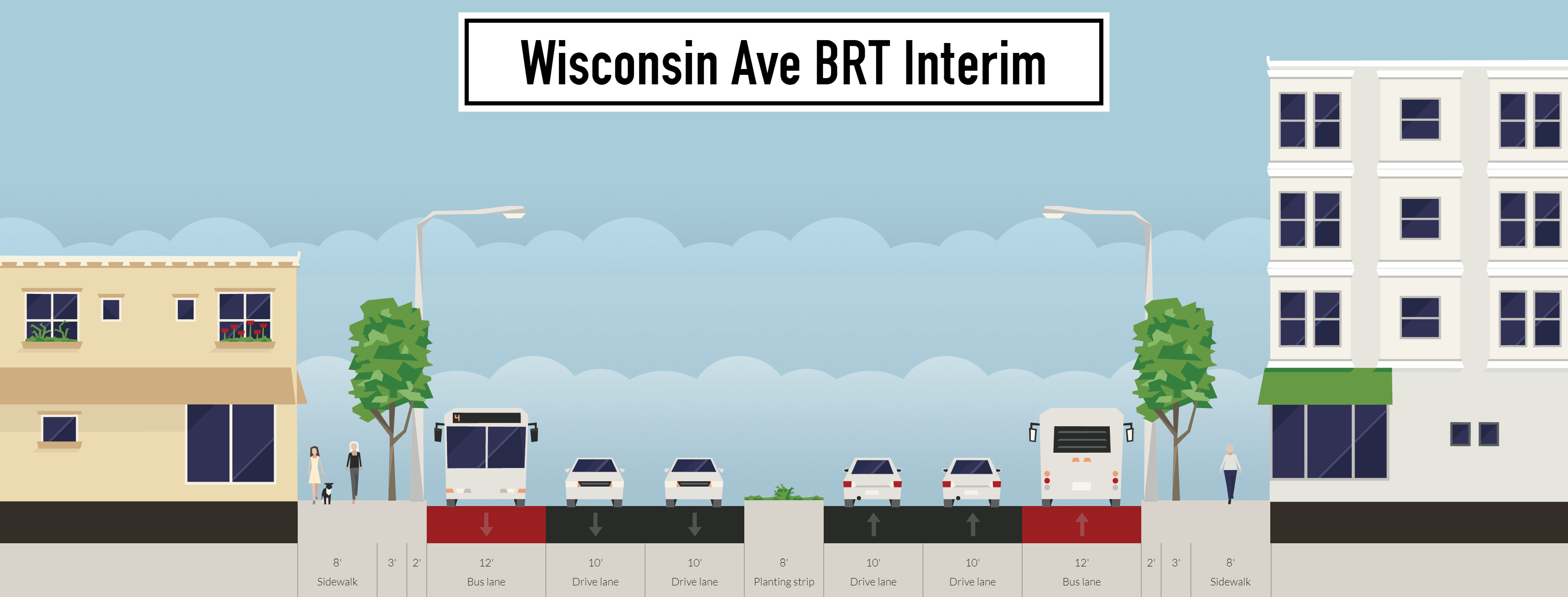
Including a paint-only option as a community organization is important, since many states have rules preventing construction on a road more than once every few years. While the NACTO design guide is still pretty new to a lot of professional transportation engineers, relying on an approved guide should at least get you past the initial skepticism during the public outreach phase. A link to the Streetmix design is here.
In this particular case however, I could not think of a much better way to improve the road given the space constraints. Sharrows do nothing, and are possibly even harmful. Despite the need for a bicycle corridor in the region, there is not much room for one on Wisconsin Avenue, although there is much more room further up Rockville Pike. In the Bethesda section of MD-355, it likely makes more sense to but a two way bicycle track on Woodmont Ave or cut through one of the neighborhoods on the side instead, although I certainly have not investigated this in detail.
What next?
While I would not say that Streetmix is revolutionary, it has been a big game changer for advocates and smaller Departments of Transportation for a long time now. I have felt for a long time now that people underestimate the importance of presentation in encouraging engagement from both communities and agencies. The material beneath still needs to be substantive, but attractive graphic design can help foster excitement. Streetmix will not teach you how to design roads, but it can help you understand what problems planners and engineers face, while allowing almost anybody to come up with plans for the streets they use every day.